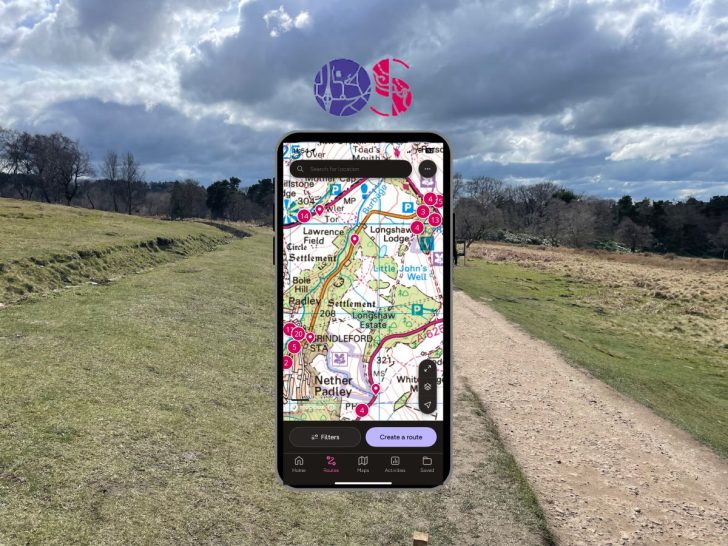

As digital maps become indispensable for outdoor adventures, the OS Maps App stands out as a crucial tool for explorers across the UK.
Designed for hikers, cyclists, and nature enthusiasts, this app offers detailed Ordnance Survey maps, offline GPS capabilities, and intuitive route planning.
Whether you’re trekking through rugged landscapes or enjoying a leisurely countryside walk, the OS Maps App ensures you have all the navigational support you need right at your fingertips.
Let’s get into the review:
Verdict:
“In my opinion, the OS maps app is the best hiking app on the market for planning and using for walks in the field. With the detailed OS Explorer and Landranger maps as well as offline GPS capabilities make the subscription well worth it.” – Alex Hesp-Gollins (Owner of PeakDistrict.org)
My rating: 4/5
But don’t just take my word for it; others also seem to agree with the OS maps app review:
Apple App Store: 4.7/5 (55.5K Reviews)
Google Play Store: 3.1/5 (17.8K Reviews)
TrustPilot: 4.5/5 (2.1K Reviews)
🟢 Pros
- Simple Route Management: You can easily create, track, and follow routes for hiking, running, cycling, and more.
- Ready-to-Use Routes: Offers a selection of premade routes for various levels.
- Unlimited Map Printing: Print as many maps as you need from the web platform.
- Comprehensive Map Coverage: Access all 607 OS Leisure maps covering Great Britain and Northern Ireland, widely recognized and used by hikers and professionals alike, including the DofE, Scouts, the British Mountaineering Council, Armed Forces, Mountain Rescue teams, and many more.
- Offline Map Downloads: Carry your maps with you without needing an internet connection while keeping live GPS capabilities.
- Cross-Platform Compatibility: Use it on web browsers, mobile devices, tablets, and smartwatches.
- Complimentary Access: Free access to the digital version of any paper map you own.
🔴 Cons
- Limited Social Features: Offers fewer options for community engagement compared to some other options.
- Geographic Limitations Outside UK: Its main functionality is restricted outside Great Britain and Northern Ireland, making it less useful for international trekers.
- Learning Curve for Beginners: While OS Leisure maps are packed with detail, they might initially overwhelm new hikers. However, mastering these maps can significantly enhance your navigation skills.
- Platform-Specific Complaints: There have been reports of bugs and issues, particularly in Android devices. Although this cannot be universally verified, it appears that the developers are actively working on updates and improvements to address these concerns.
MARCH 2024 App Update: The app recelty got a facelift with changes to the layout and display screens with the main to make things easier to access and more initiative to use. I personally don’t mind the new design, although some prefer the old layout.
Premium Subscription VS Free
The cost is simple – £34.99 per year (£2.92/month)
This subscription gives you access to all 607 OS Leisure maps. Even if you use it just a handful of times each year, it is well worth the cost, in my opinion.
Cheaper option: If you only hike in a limited area, another option could be to buy a paper map, which comes with a digital copy that you can use on the app. You can identify the maps with a mobile download by the blue ‘Includes mobile download’ badge on the cover, allowing you to redeem the map. However, it’s not possible to view these maps via the website.
Table Break Down the Main features
| Feature | Free | Premium |
|---|---|---|
| OS Standard Mapping worldwide | ✓ | ✓ |
| Plot, record, and follow routes | ✓ | ✓ |
| OS Explorer and Landranger Mapping | X | ✓ |
| Global snap-to-path | X | ✓ |
| View purchased maps offline | ✓ | ✓ |
| Import and export routes | X | ✓ |
| Aerial 3D | X | ✓ |
| Save maps offline | X | ✓ |
| Print A4/A3 maps | X | ✓ |
Here’s an overview of the main features of the App:
OS Standard Mapping Worldwide (Free)
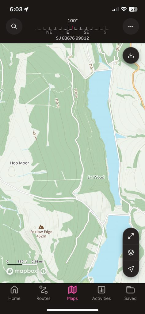
The paths and tracks that are displayed on the standard OS mapping are not necessarily rights of way data complied from various sources which are not always accurate.
Standard and satellite mapping coverage is also available globally, not just within the bounds of the UK.
Plot, Record, & Follow Routes (Free)

Within the app or web app (on your computer or tablet), you can plan your route in advance and switch between devices when you get outdoors, where you can record the activity and easily follow the route.
Global snap-to-path (Paid)
The snap to path feature allows you to dot points on the map in large distances and let the software align the exact route on the path making in more efficient and quicker than having to very closely plot the route over the path.
Import & Export Routes (Paid)
Routes can be imported or exported using the GPX file feature, which allows routes to be compatible with almost any GPS device or software.
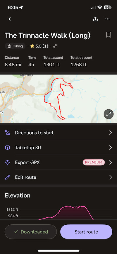
Offline Download OS Explorer & Landranger Maps (Paid)
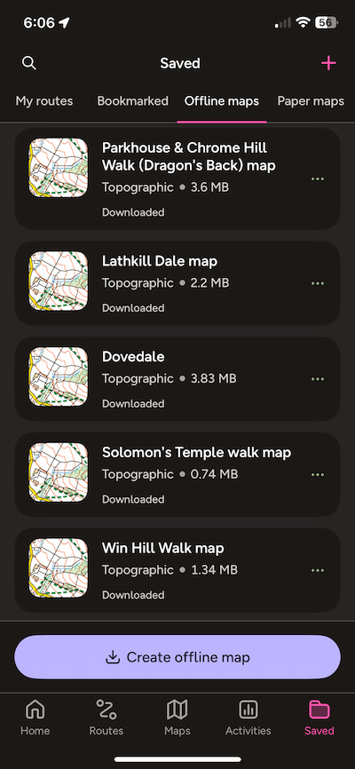
The primary feature of the paid Ordnance Survey maps app is the option to download Landranger and Explorer maps for offline use. This flexibility allows you to store and zoom into the UK’s maps on your smartphone, capturing all the details you’d find on paper maps, from contours to walls.
IMPORTANT: Ensure you download the route before you arrive, and check that it says ‘complete’. I’ve closed the app prematurely more than once, which meant I had to revert to the paper map in the field due to a lack of signal. However, this is exactly why carrying a paper map and compass is always a good idea! 🙂
If you purchase an OS paper map, look for the “includes mobile download” label, which will grant you access to some of these features.
GPS Tracking
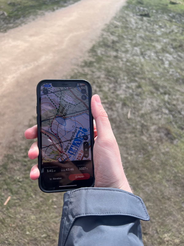
If your phone is equipped with a GPS chip, compass (magnetometer), and motion sensor — features found in most smartphones and iPhones — it can accurately track your location on the map, even without a signal.
From personal experience, the app’s reliability in conditions of poor visibility has proven invaluable. This highlights its significance for safety and navigation in challenging environments.

Print A4/A3 Maps
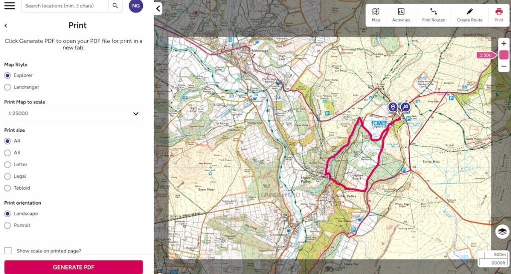
You can print unlimited A4 or A3 paper maps, which makes it really easy to select just the tiles you need with the route already marked.
This way, you can easily slide the map into a sleeve, and off you go.
Here’s a great short video that discusses most of these features:
Safety Considerations: Not Fully Relying on the OS Maps App
While the OS Maps App is a valuable tool for navigation, relying solely on any digital app can be risky, especially in remote or challenging environments. Here are essential safety considerations to keep in mind:
- Portable Charger: Always carry a portable charger. Digital devices can run out of battery quickly, especially in cold weather or when using GPS functions extensively.
- Paper Maps and Compass: Always have a paper map and compass as backups. They don’t require batteries and are crucial if your digital devices fail.
- Map Printing: Utilize the OS Maps App’s feature to print only the A4 sections you need. This can lighten your load while ensuring you have reliable, physical maps of the areas you’ll explore.
Adopting these safety measures will enhance your preparedness and ensure a safer hiking experience, keeping you ready for any situation where technology might let you down.
Ordnance Survey Map App Tutorial
If you want a comprehensive overview of using both the web and mobile app, watch this full tutorial and official video about how to use the app:

Keep in mind that the video is a bit outdated, but it closely matches the current functionality and layout of the new OS app.
OS Maps App Alternatives
When exploring alternatives to the OS Maps online app for UK hiking, AllTrails and Komoot are notable contenders, each offering unique strengths and popular with a range of walker.
AllTrails: Community-Powered Trail Discovery

AllTrails shines with its vast trail database and user-generated content, featuring over 400,000 global trails. It’s user-friendly, with powerful search filters to match hiker needs by trail difficulty, length, and more, with some of the most detailed route photography and community advice.
Pros:
- Extensive trail options worldwide
- Strong community interaction
- Intuitive interface
Cons:
- Inconsistent detail across trails.
Less focused on UK-specific hiking.
Komoot: Customized Outdoor Route Planning
Komoot is renowned for its detailed, customizable route planning and offline map capabilities, ideal for both hiking and biking. It leverages community insights for enriched outdoor planning as well, although it seems to be slightly less popular than All Trails.
Pros:
- Advanced route customization
- Useful offline navigation
- Diverse activity options
Cons:
- Premium features require a paid subscription
- Feature complexity might overwhelm beginners
Both apps enhance hiking experiences with distinct focuses: AllTrails on community-driven trail exploration and Komoot on personalized route planning, although neither I would say are better than OS maps in the UK due to the interior maps.
View the full review of the Best UK hiking apps I’ve been using for a more detailed overview.
OS Maps App Review – FAQs
How much does OS Maps app cost?
The OS Maps app offers various subscription plans, including a monthly and an annual option. At the time of writing, the cost is £34.99 per year (£2.92/month).
Can I use OS Maps for free?
Yes, OS Maps offers a free version that provides basic mapping features. However, access to premium OS Leisure maps features requires a subscription.
Does OS Maps work without signal?
Yes, OS Maps can work offline. You need to download the necessary maps while you have an internet connection first, and then you can access them without a signal.
Does OS Maps use GPS?
Yes, OS Maps uses GPS to provide real-time location services, helping you navigate and track your routes accurately, even without a phone signal.
Why do people use OS Maps?
People use OS Maps for detailed and reliable navigation in outdoor activities such as hiking, cycling, and walking. The app offers a wide range of maps that are especially useful for exploring rural and wilderness areas of the UK.
Can you cancel OS Maps subscription?
Yes, you can cancel your OS Maps subscription at any time. The process depends on how you subscribed (directly through the website or via an app store), so follow the appropriate procedure from there.
How often do OS Maps get updated?
OS Maps are regularly updated to ensure accuracy and reflect any changes in the landscape. The frequency of updates can vary depending on location.
How do I download OS Maps to my phone?
To download maps to your phone, open the OS Maps app, select the area of the map you want to download or select the route, and follow the prompts to save it for offline use. Make sure you have enough space on your device to store the maps.
Jane Bowden
Thursday 10th of October 2024
Really helpful review. Much better than the OS website! I can’t walk now although I was an avid long distance walker. I have been using the old OS maps app for finding my way round towns in the car and just simple looking up places and terrains. Wondering if I’d find any particular advantage in the new app?
Alex Hesp-Gollins
Thursday 10th of October 2024
Glad you found it helpful! :) I don’t think there’s much difference—it's more of an interface update from what I’ve seen. Ultimately, the OS Maps are still the same maps.