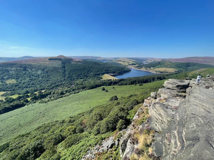

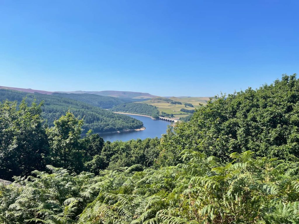
Bamford Edge boasts stunning views over the iconic Ladybower Reservoir in the heart of the Peak District.
Whether you’re an experienced hiker or prefer a relaxed walk, this guide covers everything you need for the journey ahead.
I’ll tackle parking concerns, provide insider tips, and walk you through both the direct and circular routes.
Lace up – your adventure awaits!
Getting to Bamford Edge
Getting to Bamford Edge is best accessed by car as it is usually the quickest and most direct option. However, there are fairly good transport connections with a train station in Bamford. Rare for many popular peak district spots.
Bamford Edge – By Car & Parking
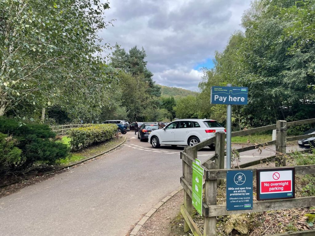
By car, you have the main Heatherdene car park. There are also free layby where you can park, but these can tend to get full.
What Three Words: ///halt.bandaged.hindering
Postcode: S33 0AQ
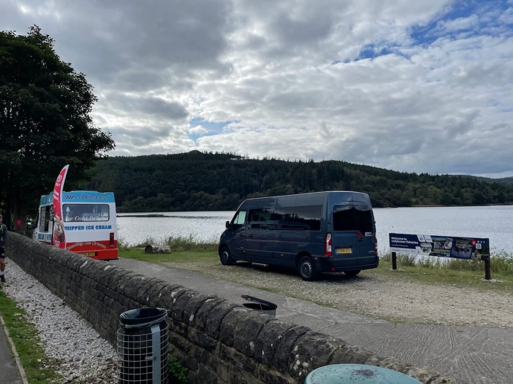
Heatherdene car park is a major parking area for the Ladybower reservoir, with ample parking and great access to this route to Bamford Edge.
Price update: As of October 2024, the price was £3.50 for 2 hours or £6.00 for all day. You can pay via contactless or use coins, should you prefer.
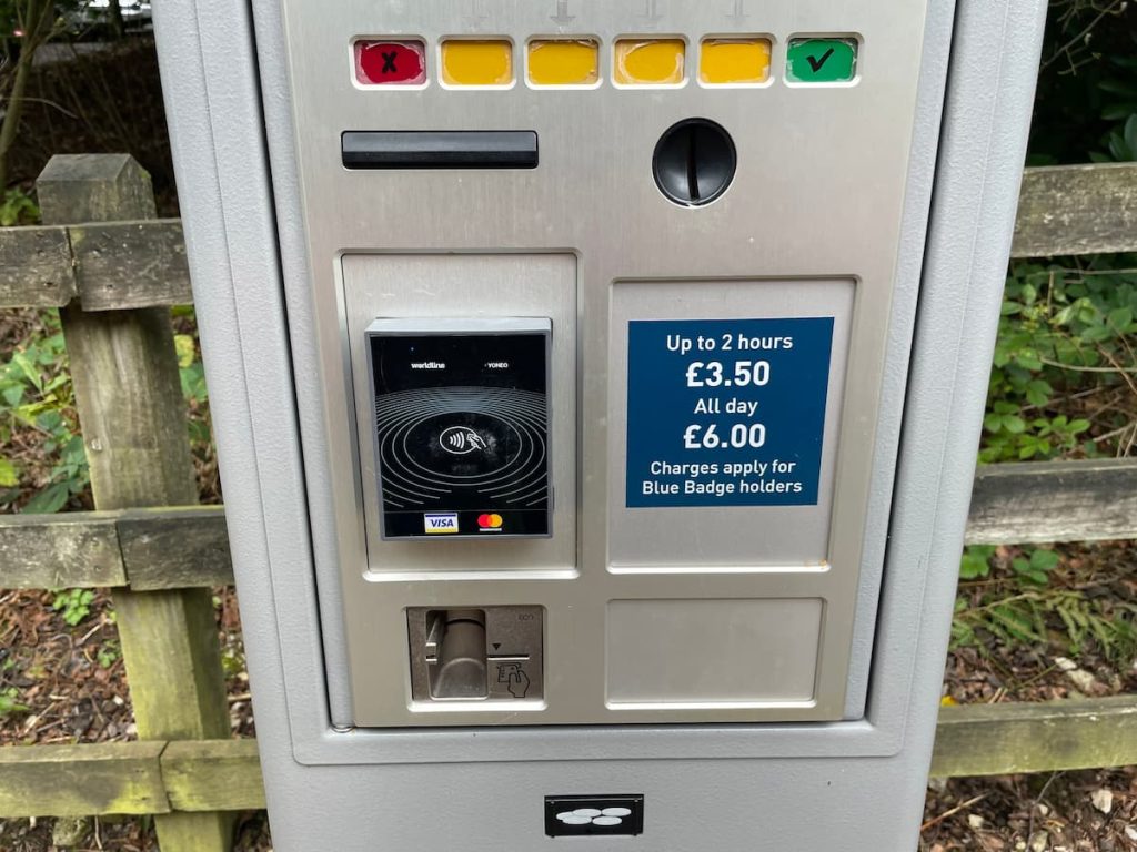
Most walks to the major landmarks in the area, including Bamford Edge or Win Hill, will usually take over 2 hours, so it’s probably safest to get all-day parking.
The car park also has toilets, water fountains, and, on a hot summer’s day, an ice cream van near the reservoir.
- Layby
What Three Words: ///visits.completed.truck
Postcode: Not accurate enough
New Rd, has free laybys, but there are only 10-15 spaces, so it can get quite full.
If you park here, you’ll join the route further along, but you can still quickly access the Bamford Edge viewing point (the closest access) or do the full walk mentioned in this article.
Public Transport Options to Bamford Edge
There are surprisingly good public transport options, with a train station in Bramford and a regular bus route that passes by.
Train
There’s a Northern Line train from Sheffield-Manchester which runs hourly, stopping at Bamford Station, followed by a 15-minute walk to Bamford village, where you’ll be able to join the circular route, which goes to Bramford edge, or go anti-clockwise to get direct access to the route.
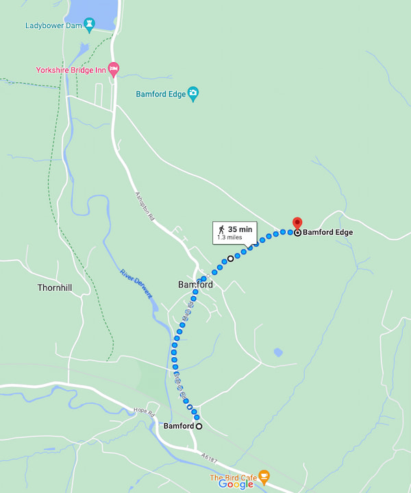
The above image shows the walk from the train station to the nearest accessible point to reach the Bamford edge viewing point.
Bus
Bus 257 Bakewell, which runs from Sheffield, stops right outside Heatherdene’s car park, so it could also be a good option.
Bamford Edge Walk Maps & Routes
🔵 Medium | 🚶♂️ 5-9 km (3-6 mi) | ⛰️ Total Ascent: 210-320 m (690-1050 ft) | ⏱️ 1.5-3 Hrs
Download file for GPSA: A direct 5km (3.3mi) walk that climbs quickly and steeply from Heatherdene car park to the Bamford Edge viewing point, at which point you will return down the same route.
B: The alternate 9km (5.5 mi) route offers a round trip, passing through the village of Bamford before looping back, crossing the base of the Ladybower reservoir and eventually rejoining the car park.
A. Direct 5km (3.3mi) Route – View OS Map
B. Circular 9km (5.5 mi) Route:
Which hiking map app should I use? I recommend OS Maps Online for its unparalleled accuracy. However, if you’re a beginner, you might find AllTrails to be more user-friendly. For a detailed review of the best UK map apps, read my full review.
1.A&B. Start by following the path out of Heatherdene Car Park, passing the public toilets for several hundred metres until you reach a fork. Here, take a left turn into a forested area.
2.A&B. Navigate through this forested area and into a clearing used for power lines; continue following the path until you encounter a wall, which you’ll need to cross.
3.A&B. The next stage is a steep ascent up the hill along a path. At this point, you might also be able to spot the cliffs of Bamford Edge. Please note that the paths in this section split and can be quite overgrown, but they all generally lead upwards, away from the tree line.
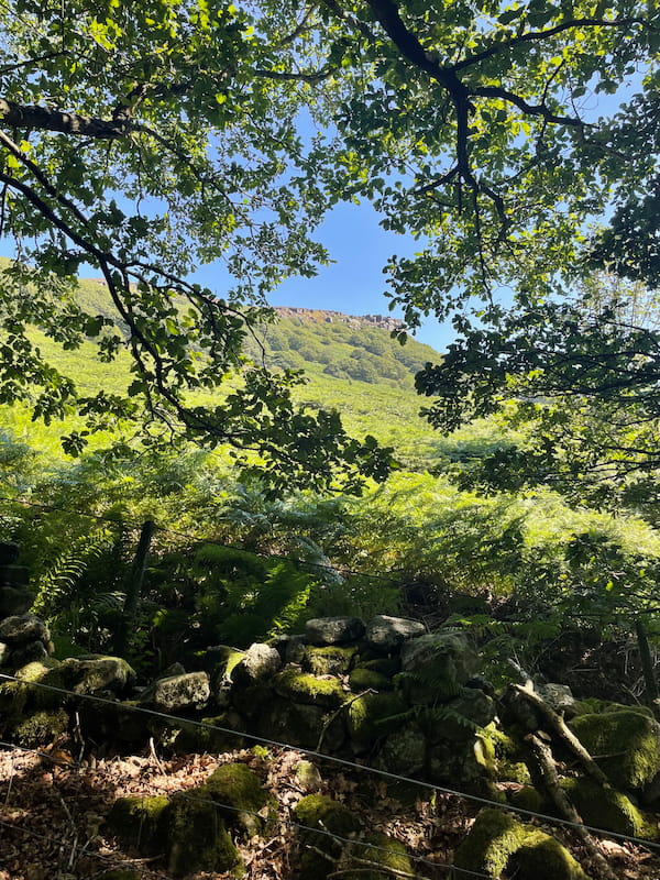
4.A&B. With the Ladybower Reservoir in clear view behind you, you’ll keep accessing until past the treeline.
5.A&B.The path ahead will meet another from the left. Take a right turn here, slowly gaining more height, and you should soon see Bamford Edge ahead of you for the next 1km.
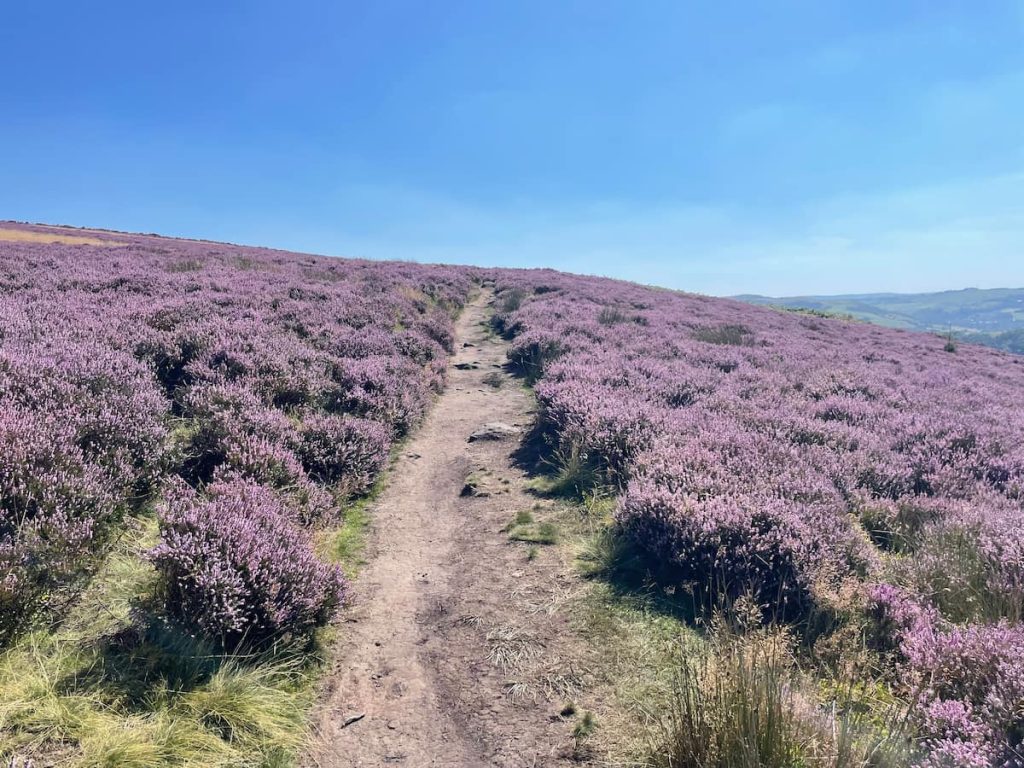
6.A&B. Once you’ve reached the iconic Bamford Edge cliffs, take a moment to snap some pictures.
If you’re on the short, direct route, this is your turnaround point. If you’re on the longer, circular route, continue along the path by the cliffs.

7.B. Now, at the route’s highest point, your journey from here is mostly downhill. Continue to follow the path down until you reach a road with a layby (which also serves as alternative free parking).
8.B. When you reach the road, take a right and bear left off the road just 100m down, onto a downward-sloping track covered by trees.
9.B. Follow this track downhill until you reach the village of Bamford. Here, you might want to take a break at The Angler’s Rest, the only major place for food and drink along the route.
10.B. Walk through the village and cross the river on a small wooden bridge at Bamford Mills, where you’ll rejoin the footpath.
11.B. Follow the path until you reach the bridleway, which you can then follow all the way back to Ladybower Reservoir.
12.B. Once at the reservoir, cross over on the path, then cross the main road to join the original path leading out of the car park. Simply follow this path back to reach Heatherdene Car Park.
- Daypack: Choose a 10-20L daypack to carry all your gear comfortably.
- Clothing: Wear layered, moisture-wicking clothing and pack a waterproof jacket and waterproof trousers for changing weather.
- Footwear: Sturdy walking boots or trail shoes are essential for the varied terrain.
- Water & Snacks: Carry enough water (at least 1L per hour) and bring energy-rich snacks.
- Navigation: Always have a map and compass, and optionally, bring a reliable GPS app to stay on track.
- First Aid Kit: Include essential items like blister treatments and painkillers. A compact First Aid Kit is ideal.
- Emergency Items: A headtorch, whistle, and multi-tool can be vital in unforeseen situations.
Please note some of these links may earn us a commission from qualified purchases at no additional cost to you, which helps fund the free content we provide.
Bamford Edge Amenities & Facilitates
It’s important to note that there are no amenities directly on or near the Bamford Edge viewing point, so prepare accordingly before their walk.
Heatherdene Car Park serves as the starting point for the walks, and it offers some facilities. Here, you can find public toilets and a water fountain. Additionally, on sunny days, you’ll often find an ice cream van stationed here, perfect for a refreshing treat.
For those undertaking the longer, circular route, the village of Bamford offers additional amenities. The Angler’s Rest, a local pub, is an ideal spot for rest and some nourishment and has good reviews (However, it is closed on Wednesday and Thursday). The village also has public toilets for your convenience.
If you require additional supplies, the nearest shop is the Texaco petrol station located near the train station. While it may not offer a wide variety of goods, it can provide basic supplies for your walk.
Bamford Edge Walk – FAQS
Here are some commonly asked questions about Bamford Edge and the walk:
How long is the walk around Bamford Edge?
The walk around Bamford Edge varies in duration depending on the chosen route.
The direct route typically takes between 1 and 2 hours, while the circular route can take between 3 and 4 hours. Extra time should be factored in for photography and lunch.
Can you walk on Bamford Edge?
Yes, Bamford Edge is a popular walking area with beautiful views and well-established paths.
The rocks at the viewing point can also be walked and sat on, but be careful of the drops.
How do you climb Bamford Edge?
The article outlines a detailed route to climb Bamford Edge. Simply follow the directions and maps provided.
How to get to Bamford Edge from Bamford Station?
Bamford Station is well-connected by the Northern railway line from Sheffield-Manchester.
After disembarking at Bamford Station, it’s a 15-minute walk to Bamford village.
From there, you can join the circular route to Bamford Edge or take a direct route.
Is Bamford Edge steep?
Yes, there are steep parts of the Bamford Edge walk, particularly the ascent towards the viewing point.
How high is Bamford Edge?
The highest point on the Bamford Edge walk, at the iconic viewing areas, is 390 meters (1280 ft).
What is the postcode for the Bamford Edge walk?
The postcode for the starting point of the Bamford Edge walk at Heatherdene Car Park is S33 0AQ. For a more exact location, you might also want to use the what three words ///halt.bandaged.hindering.
If you enjoyed this walk, be sure to explore other edge walks nearby, like Stanage Edge or Curbar Edge, both just a short distance away.
Sierra_L
Thursday 4th of July 2024
How do you climb Bamford Edge? Is there like, a specific spot or path best for beginners? Not looking to accidentally go on a wild adventure, haha.
Jo M
Monday 3rd of June 2024
The walk maps & routes section is so helpful! Always looking for new paths to try.
Nikki H
Thursday 4th of July 2024
any recommended spots for photography?
Daz K
Monday 1st of April 2024
great, more tourists. just what bamford edge needs.
Robyn87
Wednesday 28th of February 2024
is bamford edge the new leg day? asking for a friend who defo skips it haha
Ella F.
Thursday 21st of December 2023
love that there's public transport options to bamford edge! doing our bit for the planet while enjoying nature.
Sam R.
Thursday 4th of July 2024
Absolutely!
Chris P.
Monday 29th of April 2024
wish more people thought like that, most just drive and leave litter